


RF Planner
Mô tả của RF Planner
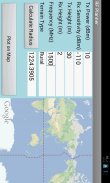
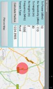
This is a simple application which can be used to do RF planning of a GSM, WCDMA, LTE or WiMAX site. The input parameters are the Tx Power, Rx Sensitivity, Tx Height, Rx Height and Frequency of operation. The output parameter is the Cell Radius which is used to plot the coverage area of the cell site on Google Maps. The coverage scenario can be selected from the following three options:
1. Urban
2. Suburban
3. Rural
The underlying model is applicable to Frequencies of up to 3500 MHz, Distances of 100-8000 m, BS Antenna Heights of 10-80 m and MS Antenna Height of 2-10 m.</div> <div jsname="WJz9Hc" style="display:none">Đây là một ứng dụng đơn giản mà có thể được sử dụng để làm quy hoạch RF của một GSM, WCDMA, LTE hay WiMAX trang web. Các thông số đầu vào là điện Tx, Rx Sensitivity, Tx Chiều cao, Rx Chiều cao và tần số hoạt động. Các tham số đầu ra là Radius di động được sử dụng để vẽ vùng phủ sóng của các trang web di động trên Google Maps. Các kịch bản bảo hiểm có thể được lựa chọn từ ba tùy chọn sau đây:
1. Đô thị
2. Suburban
3. nông thôn
Các mô hình cơ bản được áp dụng cho tần số lên đến 3500 MHz, Khoảng cách của 100-8.000 m, BS Antenna Heights của 10-80 m và MS Antenna Chiều cao 2-10 m.</div> <div class="show-more-end">
RF Planner - Phiên bản 1.0
(13-06-2016)RF Planner - Thông tin APK
Phiên bản APK: 1.0Gói: com.raymaps.rf.planner1Phiên bản mới nhất của RF Planner


Ứng dụng cùng danh mục

Bạn cũng có thể thích...
 4.044.344.073.72
 4.06
4.06


